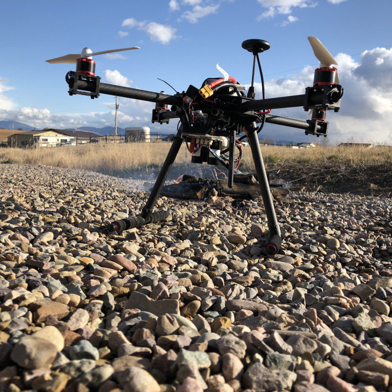
Made from off-the-shelf hardware, including a Raspberry Pi 3A+, the Hot Spotter can survey an area to create a heat map. “As the drone flies over an area, it records average temperatures of spots on the ground,”explains Jason. “The size of the spot depends on how high the drone is flying, in the same way the spot size from a flashlight depends on how far away it is from a surface.”
The software creates an imaginary grid of points, spaced about one metre apart, to be used for the heat map. When the drone takes a temperature reading of a spot, it’s recorded for all the points contained within it. Then, when the heat map is generated, all the readings for a given point are averaged together. “This method helps to localise heat sources and distinguish between large warm regions versus hot spots.”
As the drone flies a cross-hatch pattern to survey the area, its on-board GPS is used to determine its precise position while a lidar module measures the distance to the ground. This results in more accurate heat mapping than when estimating the height, as well as opening up the possibility of terrain following and obstacle avoidance.

Altitude testing
“For my tests, the drone flew about 20 metres above the ground,” says Jason. “I would like to test at other altitudes. Since the size of the spot being measured increases with altitude, the drone can cover more area from higher altitudes at the expense of heat map fidelity. Ideally I would like to create a quick map from a high altitude followed by a higher fidelity map at a lower altitude for regions that look like potential hot spots.”
The on-board Raspberry Pi 3A+ communicates with the drone’s flight controller (using the MAVLink protocol) to receive information such its GPS position and orientation. “Raspberry Pi handles all of the calculations necessary to generate a heat map from sensor data recorded by the drone and from sensors attached directly to the GPIO using an I²C hub,” says Jason. “Raspberry Pi can also command any autonomous functions such as setting a waypoint and returning to its launch point.”
It sends the data in real-time – using a wireless serial connection via a 500 mW transmitter – to a ground station laptop via another Raspberry Pi used as a wireless hotspot for a laptop.
Crash landing
It took Jason three months to build and program the Hot Spotter. However, after numerous successful test flights, disaster struck when the drone crash-landed due to a malfunctioning rotor. “It was a bummer to say the least,” he says. “I have rebuilt the drone. Better than it was before. Better… stronger… faster.”
While he thinks the drone’s practicality is solid from a cost standpoint, its practicality ‘in the wild’ remains to be seen. “I would like to do further testing that includes real-world scenarios. There is a fire science laboratory near me and if they find it useful, the project might have a future there.”
Schreibe einen Kommentar
Du musst angemeldet sein, um einen Kommentar abzugeben.